In a building or infrastructure project, geotechnical design requires the stress changes induced by the proposed structure to be evaluated together with the response of the soil or rock mass. The ground profile, groundwater conditions, foundation and excavation geometry, adjacent structures, construction stages and seismic effects directly influence the selection of the foundation system, excavation support solution, ground improvement method and other geotechnical design decisions.
Geotechnical design is the process of engineering interpretation of data obtained from field and laboratory investigations, development of an idealized Ground Model, determination of geotechnical design parameters, comparison of appropriate engineering alternatives, and development of the calculations, details and construction requirements for the selected system. Depending on the nature of the project, this process may include foundation design, excavation support design, ground improvement design, slope stability, geosynthetic systems or geotechnical earthquake engineering studies.
The Turkish Building Earthquake Code (TBEC 2018) distinguishes soil and foundation investigation reports into a Data Report, in which the results of ground investigations are presented, and a design-oriented Geotechnical Report. The Geotechnical Report is required to establish the Ground Model, define geotechnical design parameters, evaluate foundation system alternatives and carry out the necessary engineering analyses (AFAD, 2018). Geotechnical design is the subsequent stage in which these data are integrated with the structural and site conditions to develop a practical engineering solution.
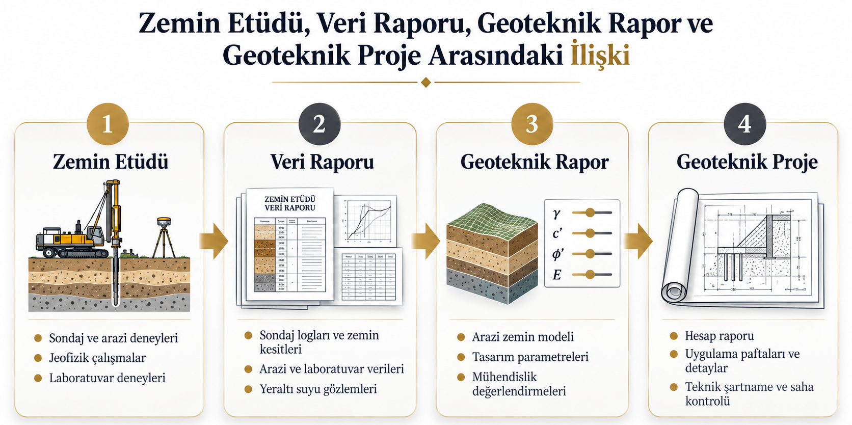
Difference Between Ground Investigation, Geotechnical Report and Geotechnical Design
A clear distinction between these stages is important for understanding the scope of geotechnical engineering and design.
Ground investigation comprises the field and laboratory studies planned to characterize the soil, rock and groundwater conditions at a project site. Boreholes, sampling, in-situ testing such as SPT, PMT, DMT and CPTu, geophysical surveys and laboratory testing may form part of the investigation program depending on project requirements. The 2019 Turkish Communiqué on the Implementation Principles and Report Format for Soil and Foundation Investigation requires ground investigations to be planned by considering the characteristics of the proposed structure, geological conditions, adjacent structures, groundwater and regional seismicity (Ministry of Environment and Urbanization, 2019; 2021).
The Data Report is the report in which information obtained from field and laboratory investigations is systematically presented. According to TBEC 2018, the report includes investigation borehole and trial pit logs, subsurface profiles, groundwater levels, field and laboratory test results, and findings from geophysical investigations (AFAD, 2018).
The Geotechnical Report is the stage at which the available data are interpreted for design purposes. A Ground Model is developed, geotechnical design parameters are established for the identified ground units, foundation system alternatives are assessed, and bearing capacity, settlement and other necessary engineering analyses are performed. Where ground improvement is required, alternative methods are evaluated; design parameters for temporary or permanent excavation support systems and, where applicable, slope stability assessments are also addressed within the report (AFAD, 2018).
Geotechnical design, on the other hand, involves the detailed design and implementation of the selected engineering solution. Depending on the scope of work, the design deliverables may include calculation reports, design sections and drawings, element dimensions and elevations, construction details, technical specifications, construction sequencing, quality control criteria and monitoring requirements.
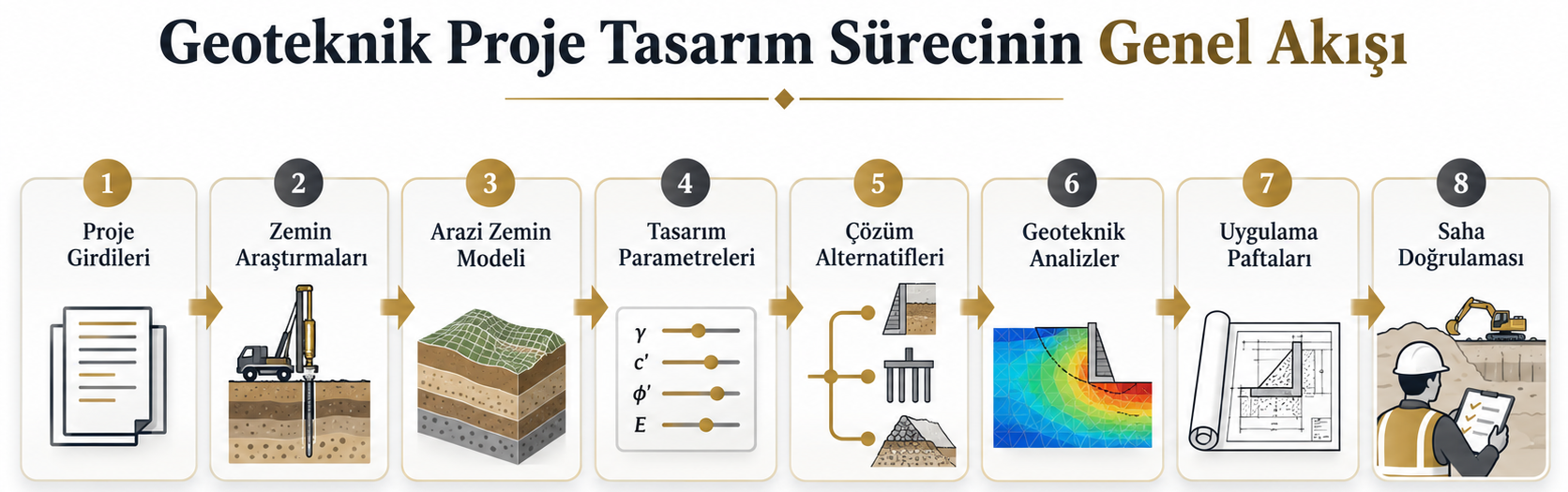
How Does the Geotechnical Design Process Work?
Geotechnical design is not a single calculation step. It consists of a series of interconnected stages, beginning with the planning of the investigation program and continuing through verification of ground conditions during construction. The scope of the process varies according to the type of structure and the geotechnical problem involved.
1. Definition of Project Inputs and Ground Investigation Requirements
The first stage involves evaluation of the structure type, loads transferred from the structural system, foundation and basement levels, planned excavation depth, site geometry, adjacent structures, existing utilities, topography and seismic effects. The ground investigation program is then developed by considering these factors together with the regional geology and available existing information.
The objective of the investigation is not merely to identify soil layers, but to obtain sufficient and representative data to reduce uncertainties that may influence design decisions. The FHWA Geotechnical Site Characterization guidance similarly considers site characterization as an integrated process involving investigation planning, characterization of soil and rock units, interpretation of design parameters, assessment of geotechnical hazards and reporting of the results (FHWA, 2016).
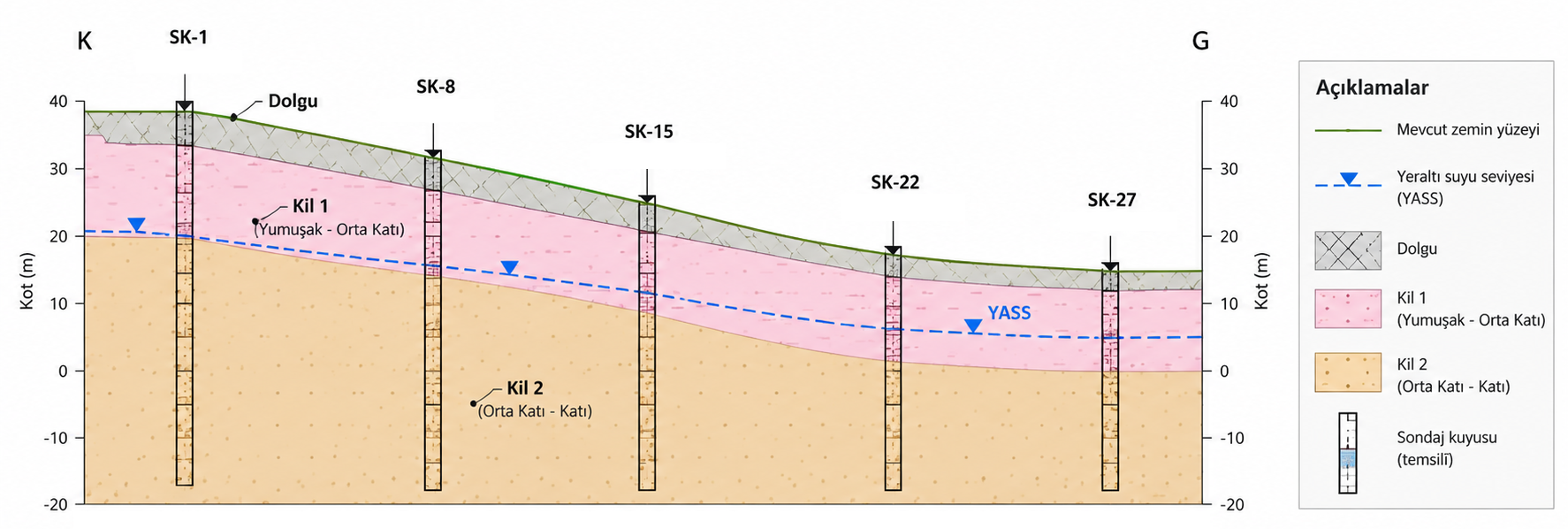
2. Development of the Ground Model
Borehole logs, in-situ test results, laboratory test data, geophysical measurements, groundwater observations, topography and available geological information are evaluated together to identify geotechnically meaningful soil and rock units. Based on this assessment, the Ground Model is developed.
A Ground Model is more than a cross-section showing borehole locations side by side. It represents the relationships between different sources of information, the likely continuity of strata across the site, groundwater conditions and the geotechnical units relevant to design. The JRC guidance published for the second generation of Eurocode 7 similarly defines the Ground Model as a site-specific representation of the disposition and characteristics of the ground and groundwater based on ground investigations and other available information (Garin et al., 2024).
Therefore, instead of directly averaging values obtained from different boreholes, stratigraphy, geological origin, test quality, stress level and project geometry should be evaluated together.
3. Determination of Geotechnical Design Parameters
For each geotechnical unit defined in the Ground Model, the parameters required for the relevant analyses are established. Examples include the effective angle of internal friction (φ′), effective cohesion (c′), undrained shear strength (cu), unit weight, deformation modulus, permeability and dynamic soil parameters.
Parameter selection should not be based on a single test result. The reliability of field and laboratory tests, sample disturbance, stress level, drainage conditions, variability within the ground unit and the applicability range of empirical correlations should be evaluated together. TBEC 2018 requires the use of drained or undrained strength parameters consistent with the loading rate and permeability characteristics of the soil (AFAD, 2018).
The JRC guidance also states that values derived from tests and field measurements should be selected to represent the relevant stress and strain levels and stress paths (Garin et al., 2024). This approach demonstrates that different parameter sets may be required for the same ground unit when addressing different geotechnical problems.
4. Selection of the Appropriate Geotechnical Solution
In many cases, more than one technically feasible solution can be developed for the same site. During the design stage, alternatives are evaluated by considering safety, deformation performance, construction method, adjacent structures, groundwater conditions, site access, construction schedule and cost.
For example, a shallow foundation may be adequate for a particular structure, whereas higher loads or compressible ground conditions may require consideration of piled foundations or ground improvement. Ground improvement alternatives may include deep soil mixing (DSM), rigid inclusions, jet grouting and stone columns, depending on the ground profile and target performance. For deep excavations, bored pile walls, secant pile walls, diaphragm walls, anchored systems or internally braced systems may be considered depending on the project conditions.
The objective at this stage is not to adopt a particular method as a default solution, but to identify the system that is technically appropriate for the specific site and structural conditions.
5. Geotechnical Analyses and Performance Checks
The scope of geotechnical analyses is defined according to the type of project and the relevant failure or deformation mechanisms. Checks such as bearing capacity, settlement, overall stability, lateral displacement and excavation base stability are selected according to the geotechnical problem being assessed.
Foundation design considers total and differential settlements in addition to bearing capacity. For piled foundations, pile capacity, group behaviour, settlement and, where relevant, lateral loading may be assessed. TBEC 2018 includes provisions requiring foundation design to consider both bearing resistance limit states and displacement or settlement criteria (AFAD, 2018).
For excavation support systems, the assessment typically includes earth and hydrostatic pressures, structural member forces, lateral displacements, excavation base stability, overall stability, effects on adjacent structures and utilities, and construction stages. In slope projects, potential failure mechanisms and stability conditions are evaluated, whereas ground improvement design focuses on the required bearing capacity, settlement, strength and stiffness performance criteria.
Where seismic effects are significant for design, additional assessments may include liquefaction, seismic performance of slopes and retaining structures, site-specific ground response analysis and soil–structure interaction. The required analyses should be determined in accordance with the applicable codes and standards, together with the project-specific structural and ground conditions.
6. Development of Construction-Ready Design Documentation
The results of geotechnical analyses must be translated into a design that can be practically implemented in the field. Depending on the scope of work, design drawings may show system geometry, elevations, element dimensions, material properties, anchor or strut levels, pile layouts, ground improvement column arrangements, drainage details and construction sequencing.
Consistency between the calculation report and design drawings is essential. If the geometry, loads, material properties or construction stages assumed in the analyses differ from those shown in the drawings, the analysis will no longer represent the system actually constructed in the field. Where required, technical specifications, quality control testing and acceptance criteria should also be included in the project documentation.
7. Verification of Ground Conditions and Performance Monitoring
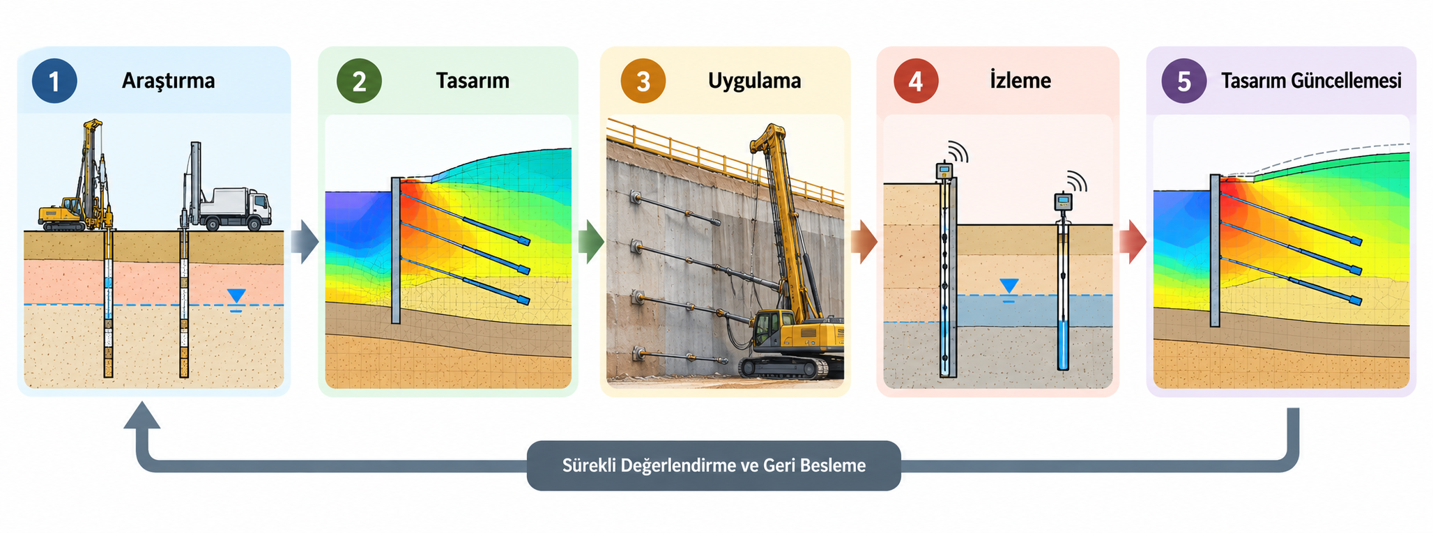
Geotechnical design is based on a Ground Model developed from information obtained at a limited number of investigation locations. Ground and groundwater conditions encountered during construction should therefore be checked against the assumptions adopted in the design.
For deep excavations, high slopes, embankments over soft ground or projects where deformation is critical, performance may be monitored using instrumentation such as inclinometers, piezometers, settlement plates, load cells or geodetic surveying. The monitoring program should be designed according to the system being assessed and the behaviour that needs to be measured.
The second-generation Eurocode 7 approach also emphasizes that the Ground Model should be progressively updated as new information becomes available throughout the project (Garin et al., 2024). Field observations and monitoring data therefore provide valuable information not only for verifying design assumptions under service conditions, but also for updating the design where necessary.
What Types of Work Can Geotechnical Design Include?
The scope of geotechnical design varies depending on the type of structure, site conditions and the geotechnical problems involved. Typical areas of work include:
- Shallow and piled foundation design, including bearing capacity and settlement assessments.
- Deep excavation and retaining system design, including bored pile walls, secant pile walls, diaphragm walls, anchors and internal bracing systems.
- Ground improvement design, including deep soil mixing (DSM), jet grouting, stone columns, rigid inclusions, preloading, vertical drains and other project-specific methods.
- Slope stability, landslide remediation and design of cut and fill slopes.
- Geosynthetic-reinforced systems, load transfer platforms and reinforced soil structures.
- Liquefaction assessment, site-specific ground response analysis and other geotechnical earthquake engineering studies.
- Geotechnical instrumentation, construction supervision and performance assessment.
Not all of these studies are required for every project. The appropriate scope should be established on a project-specific basis through the combined evaluation of the ground investigation results, structural requirements and site conditions.
Why Is an Integrated Approach Essential in Geotechnical Design?
A significant part of the uncertainty in geotechnical engineering arises from the natural variability of the ground. Stratum geometry, groundwater conditions and mechanical properties may vary across a site. Therefore, the quality of data interpretation and the ability of the Ground Model to represent the actual engineering problem are as important as the quantity of investigation data.
A foundation system that is adequate in terms of bearing capacity may not satisfy settlement criteria. A retaining system that is structurally adequate may still cause unacceptable movements in adjacent structures. Similarly, a ground improvement method may achieve the specified strength while failing to satisfy the required settlement performance. Geotechnical design should therefore consider safety, deformation, constructability and field performance together.
A sound geotechnical design process establishes a consistent relationship between ground investigation, the Ground Model, geotechnical design parameters, engineering analyses, construction details and field feedback. The quality of the design depends on considering these stages as interconnected components of the same engineering problem rather than as independent tasks.
Geotechnical Design & Consultancy
Geotech Soil and Foundation Engineering Ltd. provides geotechnical design and consultancy services for foundation systems, deep excavations and retaining systems, ground improvement, slope stability, geosynthetic applications and geotechnical earthquake engineering. Depending on project requirements, our engineering services may extend from planning of ground investigations through detailed design and construction drawings to construction supervision, instrumentation and performance monitoring.
REFERENCES
- AFAD (2018). Turkish Building Earthquake Code (TBEC 2018). Official Gazette of the Republic of Türkiye, No. 30364 (Mükerrer), 18 March 2018. Chapter 16: Special Rules for the Design of Foundation Soils and Foundations under Earthquake Effects.
- Ministry of Environment and Urbanization (2019). Zemin ve Temel Etüdü Uygulama Esasları ve Rapor Formatına Dair Tebliğ [Communiqué on the Implementation Principles and Report Format for Soil and Foundation Investigation]. Official Gazette No. 30709, 9 March 2019.
- Ministry of Environment and Urbanization (2021). Zemin ve Temel Etüdü Uygulama Esasları ve Rapor Formatına Dair Tebliğde Değişiklik Yapılmasına Dair Tebliğ [Communiqué Amending the Implementation Principles and Report Format for Soil and Foundation Investigation]. Official Gazette No. 31398, 17 February 2021.
- Federal Highway Administration (FHWA) (2016). Geotechnical Site Characterization. Geotechnical Engineering Circular No. 5, FHWA-NHI-16-072.
- Garin, H., Baldwin, M., Reiffsteck, P., van der Made, K.-J., Wudtke, R., Lamas, L., Virely, D., & Polo Lopez, C. S. (2024). Assembling the Ground Model and the Derived Values: Guidelines for the Application of the Second Generation of Eurocode 7: Geotechnical Design. Publications Office of the European Union, JRC140556. DOI: 10.2760/6390378.